
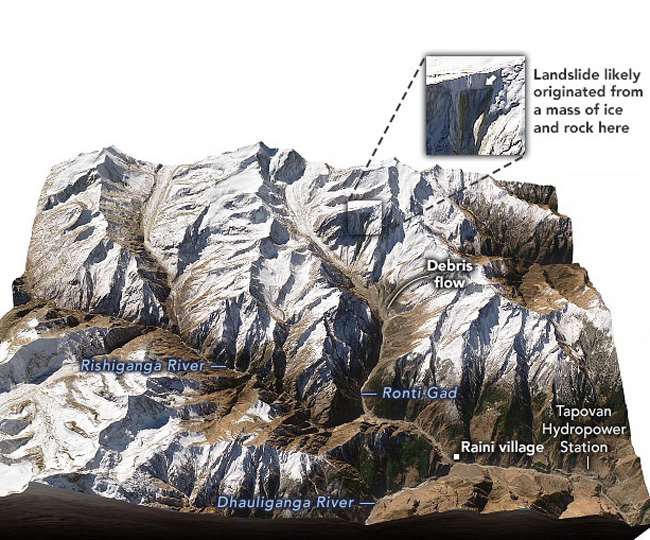
Dehradun. Through the study of various satellite images, our various scientific agencies have already clarified that the deluge that came out of the Rishiganga Commencement area was the reason for the Hanging Glacier. This glacier was Mount Rothi and the deluge came after it broke along the rock. Now the US space agency NASA (National Aeronautics and Space Administration) has told the study of satellite images that the disaster started on 20 January. Because in the satellite image of 20 January, cracks had erupted on Mount Rotheri. On this rock was the Hanging Glacier, which broke.
NASA’s Earth Observatory has also published a report titled ‘A Deadly Debris Flow in India’. The report states that the study of satellite images showed that the first cracks emerged on Mount Rothi. At the same time, there was already a load of hanging glaciers on this mountain. For some reasons, the crack continued to grow and the rock became so weak that the hanging could not bear the weight of the glacier. When the rock fell, the Hanging Glacier also fell along with it. A NASA report also states that satellite images of the Ronthee Mountains have been taken on 21 February as well. It is clear from both pictures that the crack was the cause of the breakage of the rock and glacier. Now in the latest picture, there are traces of debris left in the landslide zone of the Rownti Mountains.
The Hanging Glacier on this mountain was at an altitude of about 5600 meters and its length was about half a kilometer. The glacier hung downward at an angle of 82 to 85 degrees. Due to this, after the break, the rock and glacier had caught a rapid pace. After covering a distance of 11 kilometers in Ranthay Gadere, he fell into the Rishiganga River at an altitude of 3800 meters. Here snow and debris accumulated and an artificial lake was formed. The lake broke due to heavy pressure on the morning of February 7 and continued to wreak havoc in the lower areas, including debris.
Satellite monitoring is important
After the deluge, all scientific agencies of Uttarakhand, country and world investigated the incident and found out the real reason. Nevertheless, a question still remains as to whether something cannot be done before the disaster gets its signal. Experts are of the opinion that if the glaciers are monitored through satellite, uneven changes in the higher Himalayan regions can be detected. It is very possible that more alertness can be exercised in the lower areas by issuing some kind of warning in time.


Leave a Reply